History of the Municipality of Inden
The present-day municipality of Inden is the result of the Inden opencast lignite mine. Both the state of North Rhine-Westphalia and the mining operator wanted to deal with just one municipality – a single point of contact – regarding opencast mining planning and resettlement for their ‘lignite’ project.
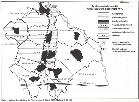
The municipality of Inden was formed on 1 January 1972 as part of the local government reorganisation. It was created from the former administrative districts of Inden and Lucherberg, comprising a total of 10 independent municipalities. Kirchberg, Altdorf, Inden and Pattern belonged to the Inden administrative district (19.77 km², 5,370 inhabitants) in the district of Jülich. Pier, Schophoven, Lucherberg, Luchem, Frenz and Lamersdorf belonged to the Lucherberg administrative district (29.41 km²; 5,813 inhabitants) in the district of Düren.
The estates of Merödgen and Lützeler were extraterritorial, i.e. they had no geographical connection to the municipality and belonged to the Langerwehe administrative district (municipalities of Luchem and Langerwehe respectively). The River Inde formed the geographical and local-government boundary between the two administrative districts and the districts of Jülich and Düren. At the same time, it marked the boundary between the Inden I and Inden II opencast mines.
The establishment of the municipality of Inden was not a voluntary amalgamation of the localities it comprised. Originally (in 1967), the administrative districts were to be merged into a ‘Greater Inden’ municipality with over 11,000 inhabitants. The plan failed because of Kirchberg and Pattern. Before 1935, Kirchberg had belonged to the Koslar administrative district. Even back then, there had been discussions about relocating Pattern and Altdorf, but not the town of Inden itself. When, in 1968, the second school reform sought to change the outdated structures of the school system – including the previous eight-year compulsory primary education, mixed-age classes and denominational schools – the two administrative districts were forced to take action. A new secondary school had to be built and jointly funded (investment volume: 7 million DM). Consequently, on 2 May 1968, the municipalities of both administrative districts merged to form the ‘Inden-Lucherberg’ school association. Kirchberg and Pattern had already agreed on schooling in Jülich and Aldenhoven respectively; Luchem and Schophoven did not join the school association until 1969. However, there was disagreement over the location of the future secondary school (an extension to the Parkschule primary school in Inden, or Merödgener Straße near the paper mill, or the Gut Merödgen area).
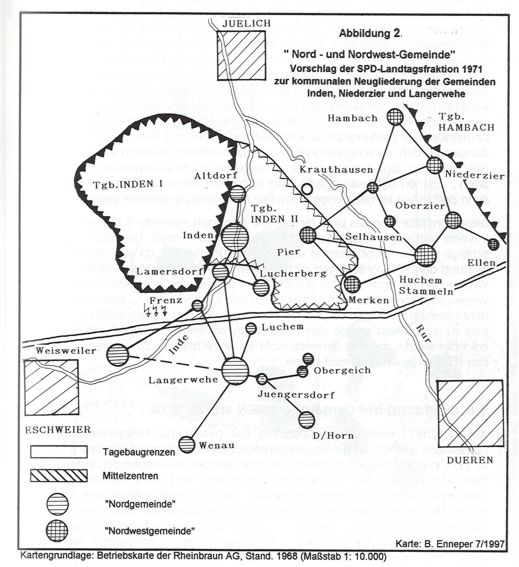
The Aachen District Government advocated the Merödgen site due to the open-cast lignite mining operations; however, the Ministry of the Interior did not wish to take the resettlement of the village of Inden into account when selecting the site. The Inden local authority drew up the ‘Study on the Spatial and Structural Development Potential of the Municipality of Inden’. It concluded that the area between Frenz, Inden, Lamersdorf and Lucherberg should become the future core area with a population of 11,000. On 25 March 1971, the municipalities of Lucherberg, Lamersdorf, Frenz, Luchem and Pier, together with the Inden-Lucherberg School District and the Merödgen Wastewater Association, signed a boundary amendment agreement.
This provided for their amalgamation into a new municipality called ‘Inden’. Further proposals followed, such as those for a northern and a north-western municipality. However, these were rejected. On 14 December 1971, the State Parliament passed the Act on the Reorganisation of Municipalities and Districts in the Aachen Reorganisation Area. It came into force on 1 January 1972.
Inden, Altdorf, Schophoven, Pier, Lamersdorf, Frenz and Lucherberg were merged to form a new municipality with a significantly smaller and differently defined municipal area. It was given the name INDEN. The administrative offices were dissolved. The town halls in Inden and Lucherberg continued to be used until the relocation to Inden/Altdorf.
Pattern, Aldenhoven and Kirchberg – with their four paper mills – were assigned to the town of Jülich, whilst Luchem was assigned to the municipality of Langerwehe. The areas south of the motorway fell to the municipality of Langerwehe; the few areas of Langerwehe situated north of the motorway were allocated to Inden. 2,817 residents (25 per cent) and 13.26 km² of land (27 per cent) from the former administrative districts of Inden and Lucherberg were thus distributed among the neighbouring municipality. Of the remaining residents, 5,400 were now to be resettled in Inden, Altdorf and Pier. 60 per cent (!) of the new municipality’s area was to make way for the Inden opencast mine between 1972 and 2030! As one of the smallest municipalities in North Rhine-Westphalia, Inden was thus not only up against a Goliath in the form of the opencast mine operator but also had to tackle Herculean tasks without any ‘resettlement legislation’ being enacted for its benefit! The town of Eschweiler took over the entire power station, including Weisweiler. The district of Jülich was dissolved. With the abolition of the Aachen administrative region, the district of Düren was assigned to the Cologne administrative region.